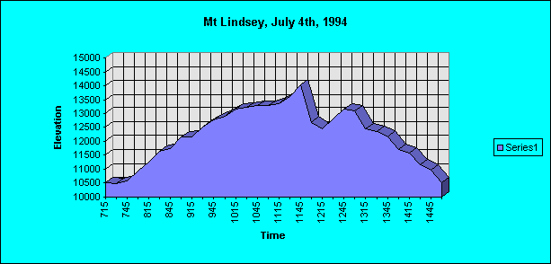
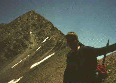
Let’s go south for a change was the cry. Rather than climbing in the Sawach Range again, Tom Vervaeke and I headed to Mt Lindsey early on the 4th of July, 4:00am to be exact. We drove in on a 22 mile 4WD road that crosses three large ranches before entering national forest property. Our only trouble on the road was dodging the multitude of deer that kept crossing the road. It was beautiful country and it was only an appetizer for what I think was the prettiest approach to a fourteener in the 18 I have done. We started hiking at 7:15, walking fast to shed the chill in the air. The trail follows a beautiful hanging meadow, and then parallels a clear running river. Some log hopping over the river got us to the “strong climbers trail” – (I am starting to hate that term.) that begin to climb steeply alongside of the river. Wild flowers were everywhere! We continued up this trail to almost 12,000′ when we broke out into a basin that was framed by Mt Blanca and Ellingwood Pt on one side and the Iron Nipple and sheer cliffs on the other. We could still not see Lindsey and we were already 1.5 hours into the approach. In the basin, we walked through fields of white daisies and kept right on the slim trail to avoid trampling any of nature’s attractions. We finally were able to see Lindsey’s pyramid top peaking over a ridge; it looked awesome!
We stopped for a food break on a grassy ramp that leads to a ridge we needed to ascend to reach the ridge on Lindsey proper. After admiring the view, we headed up the ramp and gained the sub ridge at almost 13,000.
We crossed over to Lindsey’s ridge and started up toward the north face. The books have the route going in an ascending traverse up and across the face. We started up and scrambled up the steep ledges until we reached a prominent notch. There it looked like the route led slightly down, then up around a corner. We looked at the possibilities of climbing direct to the top of the ridge, but I was a strong vote for not doing this yet; maybe we should have. I led down across a talus gully and around the corner; suddenly found myself into 5.2 class climbing with 300′ below my toes. I made the traverse to a large ledge and Tom followed about as happy as I was. :-(. We traversed left until we decided that we were off route (even though there were many signs of others being off route also in the past) at which time we reached a steep snow couloir. Tom thought the best way was to head directly up and attempt to gain the summit. It was the best way and we scrambled up the face until near the top I stumbled across the route. From there it was a short and pleasant ridge walk to the summit that we had to ourselves. Not a cloud in the sky, windy with temps probably in the 50’s. We signed the register, soaked in the views and talked about which way to descend. Choices were retracing the face climb or glissading down a couloir that started 20 feet away and went down 1400′ to 11,600′ to a valley that would require us to climb an additional 600′ back to the ridge before descending back down the trail. We opted for the glissade so outcome the ice axes!
I type this report with two fingers on my left (steering) hand taped and unusable due to this glissade; more on that later. We debated whether to put our shell pants on or go in our shorts that have a double seat in them. Tom had glissaded off Ellingwood 5 days ago in shorts and said it would be fine. OK, let’s roll! Tom did a test glissade for about 20′ and was able to stop without self-arresting. I took off and quickly gained too much speed wherein I decided to self-arrest. I did so and did slow down a bit, but although I had stopped relative to the snow, I had set off a sliding avalanche of the first 4 inches of the icy snow. Hmmm, flip back over to your rump and dig those heels in! I did this with various degrees of variation the entire way down. We heavier folks just seem to go down faster as Tom was able to control his rate of descent without self-arresting.
Did I say I declined to put my gloves or shell mittens on before starting? Halfway down, the left hand was rubbed raw by the icy crust and was soon frozen completely solid. I learned that summer icy snow is not winter soft powder snow. I did the last 300′ with the axe tucked under my armpit trying to brake as my hand was unusable. Tom passed me as we got to the bottom going full tilt. I am sure everyone has experienced the unpleasant unthawing process of a frozen digit.
My hand now entered this stage and being vocal about it seemed to help with the pain, and Tom starting issuing comforting thoughts like, “stick it in your crotch” or “stick it in the snow” After expressing myself for 5 minutes my hand game back to life except for the little finger and thumb which remains numb as of this am – not from being frozen, but from getting trashed being dragged across ice for 1400′ 🙂 Live and learn, but if only I could put all of what I learned together on one trip it would be so much easier!
We hiked back up the valley and ascended back to within 50′ of the ridge when the wind took my lucky hat and promptly blew it 200′ back where we had come from. Tom made a gallant effort to grab it, but it was moving at 40 mph with the wind. I looked down at it and debated whether to go down 200′ and climb back up. Tom said he would wait so I galloped down the ridge, retrieve the hat and huffed back to the crest. We got up and over, and back into the basin where we took a food stop. Right before we left I noticed an old pile of human excrement with some toilet paper next to me. People are people, but geezzzz. How disgusting… but hey, let’s not let that be my last memory of this beautiful trip. Tom is still laughing…
We headed back down the trail along the creek, stopping to explore a tunnel that was blasted/chiseled? out of a rock cliff? Tom explored first then invited me over to take a look. The tunnel was 3 feet wide, 4 feet high and with a completely iced floor from the winter. We slipped/scooted back to where it makes a couple of turns, and then retreated. If any Colorado folks know of this tunnel and know its history, drop me an email… we would be interested. We reached the trailhead at 3:00pm. The drive out was equally gorgeous and I will definitely come back to this area again.
Trip Distance: approx. 8 miles Elevation Gain: Approx. 4,000′


