
The data
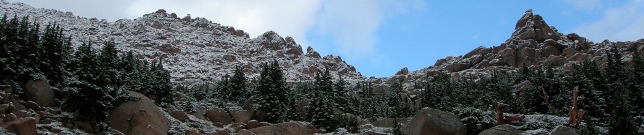
First the important stuff – the current snow conditions for this range. The Crestones, being much sharper formations and farther south have less snow on them than Pikes Peak, the Sawatch Range and peaks farther north. Crestone Needle, Peak, and Kit Carson only had snow in the couloirs and gullies, while even Humboldt only had snow near tree line, on the ridges, and in its bowls and couloirs. I call it zebra striping while the mountains I could see in the distance were still completely snow covered. Ok, that is the mountain, but the valley (South Colony lakes) is completely snow covered with deep snow that I suspect will be there until late July. The Crestones offer excellent snow climbing right now for a price — a long approach. We’ll let me not get ahead of myself, here is my story…
I was looking to climb a new 14er yesterday (#38) so I picked Humboldt Peak near Westcliffe for my attempt. With a weather forecast for hot temperature and no rain it was time to move out! Also if I made it, I would have been on top of three 14er’s in 6 days, Pikes Peak, Quandary and Humboldt. I left Colorado Springs at 2:30 under a full moon that showed off the fast running Arkansas River as I went up the canyon west of Canon City. I reached Westcliffe about 4:50 and was at the trailhead (for the Saab) by 5:10 where I was treated the sunrise over the mountains east of the valley. I parked off the road where the large rocks started and where the Saab stopped at about 8,900′. It was to be a long day. The routes described in guidebooks all have you driving or hiking to South Colony Lake where it is only a 2.8 mile, 2,400 mild walk up an “anthill”. I knew the road to be blocked by snow at about the 11,000′ point and the valley covered with deep snows. I also heard from just a week ago that the avalanche danger was high from a climber who had reported this to the local Custer County Sheriff’s office on June 5th. I got the idea of ascending the southeast ridge of Humboldt directly from low in the valley from Steve G.; a friend who had did it in a long winter day a few years ago. My hat is off to him as the climb, under full winter conditions would have probably put this beyond my stamina level.
This route would involve 5,200 elevation gain and about a 12-13 mile round trip. With the fact that I was solo and no one else would be back in there I wanted an early start and hopefully an early return. I left instructions with my wife on where I would be and an estimated time of return. I started walking up the 4wd road headed due west at 5:19 in shorts with lightweight poly pro top and bottom and reached the turnoff for the Rainbow Trail that runs north/south along the base of the mountains. I needed this trail to cross a roaring South Colony Creek (read RIVER now with the runoff) before heading west again up Humboldt. The road was in good shape and dry to that point, however by the 11,000′ point is completely still covered in snow. I headed north on the path to the creek, crossed the bridge, drew in a sharp breath and started the bushwhack up the forested ridge. You know what bushwhack means so I will not go into detail here; rocks, trees, limbs, and steep terrain! It was quite warm and mosquitoes were out from all of the water we have been having. Back at the car I debated on what to bring and what to leave. On Saturday I would have killed for crampons on Quandary and used them exclusively on Pikes Peak. Now judging my route and the warm temperature, I carried my snowshoes and no crampons. It is a tough decision to make to carry this stuff up 5,000′ but if you don’t have them, you suffer.
So here I am walking up this steep forested ridge with snowshoes strapped to my pack. Well, at about 10,500′ drifts of old snow started to appear above me through the trees. Walking through some of them I found the snow very slushy due to the high temperatures. So on go the snowshoes to break through to tree line at about 11.500 where I stopped for a bite to eat. Above me rose the SE ridge of Humboldt striped with snowfields and tundra. I had brought some wands to mark where I left tree line, but had decided to leave them in the car since I would be bushwhacking and they would get caught in the branches. I instead picked out some dead trees as markers to aid my descent.
Once above tree line I found I could traverse the 35 degree snowfield without snowshoes and I made time up to 13,000′. There was not a cloud in the sky and the temperature was warm. I compared my progress with Marble Peak to the south to see how I was progressing up the valley. When I reached the top of what I had seen from tree line I finally saw the summit of Humboldt, about 1/2 mile away and 1100′ higher. I had expected a pretty gentle ridge leading to the top as this is what you see from the south and in pictures. What I saw instead was a gentle snow covered ridge with a 1,000- 2,000 drop off to the right into North Colony Lakes drainage. Then about 700′ from the summit, the ridge took an abrupt sharp rise as it gained the summit. The snow looked pretty steep there, but I figured I would examine closer as I got higher. I hiked over to the start of the steep rise, ditched my snowshoes and trekking poles and extracted my ice axe to start the final ascent.
As I started up I noted the couloir that angles off the summit in a SE direction all of the way to tree line, dropping about 3,000′. I started to think about this as a possible alternative to retreating back to the ridge. Back to the ridge, I started up the mixed rock and snow portions, sometimes preferring to stay on the rock, and other times traversing near the ridge point on 55 degree snow. The conditions were perfect for getting good boot placements and I felt the avalanche danger was very low… but I still thought about it being alone. The nice thing about summits is that if you keep going up, they get closer. :-). Finally I was only one sharp rock step away from the top, and then there I was! Whoops, almost … the cairn I was looking seemed to be superseded by a slightly higher one on the west side of the summit. Meandering over there I found the PVC summit register in poor shape with its end cap missing and filled with soggy business cards and notes with no more space to write on them. Most were from 1994, the only two I saw in 95 were one from Jan and one from 22 May 95 by a gentleman from the US Air Force Academy,10 mins from where I live in Colorado Springs. He was also solo the note said. I extracted all of the paper and put it in my pack. As a leader with the Colorado Mountain Club, I will type up a list of names and dates and forward to the CMC, along with info that it needs a new tube cap and register.
Leaving the paper would only have destroyed the information on the scraps of paper. So here I am sitting in the warm sunshine on a clear windless days soaking in the views of Crestones with the entire place to myself. Nice way to spend an hour, eat lunch and get my strength back from what I term a bit of a difficult ascent that kept me aerobic for 4.5 hours when I reached the top at 10:00am. While on top, I took another look at the couloir that departs from the summit and sweeps down the south face in a SE direction. Clearly it would save the bushwhacking back down the ridge , clearly it would save some effort, but…. clearly my snowshoes were a 1/2 mile away and 700′ lower, lastly, clearly I was unsure if I could ford the South Colony Creek (remember, read river) running at full flow.
Back down the ridge I headed, finding going down the sharp ridge easier than going up. Once down the steep part I changed into just shorts and tee shirt and headed down to tree line with the temperature now about 70 degrees at 11,000! At tree line, I was able to cross/glissade the snowfield without snowshoes but I donned them as I entered tree line to get through the drifts. I slipped and slid down about 500′ before I was able to fasten them to my pack again. I had only needed them for a short way up and down, but I would probably still be there had I not taken them, wading through hip deep snow in that one band on the ridge! I used the roar of South Colony Creek to guide me down and actually ended up close to where I started the bushwhack on the way up. Walking along the creek I ran into the biggest porcupine I have ever seen and gave him a wide berth. I also ran into the bridge and the Rainbow Trail; almost like it was planned!
I waded in some slower moving water and used it to cool off as the temperatures now were approaching 85 degrees. I walked back down the 4wd road, back to the green pastures of the valley, and straight into summer! I emptied my last water from its bottle as I approached my car. An hour later I was in Canon City ordering a large shake, a large coke, and a large water from the first drive in I came to quench my thirst! If I had to do it all over again with the same conditions, (i.e.: a South Colony Basin one day trip is not possible) I would suggest snowshoeing up the road (although the road is as bad as most trails! :-)), then going right up that couloir to the summit, kick stepping for 3,000′ Well, just a thought. I named the route I took Swan Song. Happy wanderings. Bob
Beta: SE ridge, 5,200 elevation gain, 13 miles approx., 8 hours 26 minutes
The following is a transcript of the battered register I found at the summit. I forwarded the information to the Colorado Mountain Club:
Humboldt Peak Register Aug 94 – Jun 95 – taken from the summit 13 Jun 95
Date Last Name First Name Hometown Note
Golphreuski Artur Poland
Jakabowski Andriej Poland
Turner Pete Breckenridge, CO
8/18/94 Conger ALM and Leslie Boulder Awesome, and of course we are thinking of Faisie
8/18/94 Flits Dieter Lousiville, CO
8/18/94 Hill Dave and Elaine Boulder
8/18/94 Robinson Ira Lousiville, CO
8/19/94 AL, Mike, Dave Colorado Springs
8/19/94 King Sheri and Walter Pueblo, CO
8/19/94 Kinsek Michael
8/19/94 Lobb Del Littleton
8/19/94 Mammel Kevin Top of the world Ma!
8/19/94 Wolnia Brad Alright then!
9/4/94 Bernwell Mark Good to be on top during midlife crisis
9/4/94 Cannon Jim Beautiful
9/5/94 Hunter Norman Los Alamos
9/5/94 Hunter Patrick Los Alamos
9/5/94 Hunter Sarah Los Alamos
9/8/94 Barlett Nancy Jane Boulder CO Spectacular, Beautiful!
9/9/94 Lehman David Melbourne Beach, FL
9/9/94 Williamson Tom Melbourne Beach FL Great
9/9/94 Winston Renee Boise, ID
9/10/94 Roy Jim and Rhonda Colorado Springs #36
9/11/94 Knolles Joni Yattoo, CO a view with a crowd
9/11/94 Monnhan Yons Acer a crowd
9/12/94 Hagmeier Dan Colorado Springs same cold!
9/12/94 McDonald Merle Colorado Springs Cold. Windy
9/14/94 Goulding Charles 50 1/2 years old
Date Last Name First Name Hometown Note
9/14/94 Goulding Billy 11 1/2 years old
9/15/94 Mike and Charley Summited at 2:30am!
9/15/94 Rieo Ron Boulder CO
9/15/94 Robbins Lisa Colorado Springs. CO Awesome! wow!
9/15/94 Stallbanmer David Arvada, CO
9/15/94 Stofflet Andy Colorado Springs
9/15/94 Zerga Steve Denver, CO
9/17/94 Farquhar Dave Denver
9/17/94 Moldowan John and Sherrie Colorado Springs Our god reigns
9/17/94 Negard Randy Colorado Springs Our god is an awesme god
9/17/94 Nela Raymond Dallas, TX praise god
9/17/94 Truillo Buddy Cheyenne, WY My #2
9/17/94 Walla Jeff Colorado Springs nice and easy// CMC
9/18/94 Berends Bruce Colorado Springs
9/18/94 Geiger Greg Denver
9/18/94 Gengler Scott Denver
9/18/94 Johnson Tyler Grand Jct, CO
9/18/94 Picco Janet Durango, CO
9/18/94 Rose Warren Cheyenne, WY My second, hopefully not my last!
9/18/94 Stiner Steve Elko, NV
9/18/94 Stoddard Bob Louisville, CO
9/18/94 Stoddard Tracey Louisville, CO
9/19/94 Bcouelcamp Dale
9/19/94 Bogard Terry Pittsburg, PA
9/19/94 Logan Dan Pittsburg, PA
9/19/94 Lunn Jon Alken, SC
9/19/94 McCafferty Mike Colorado Springs
9/19/94 Roarty Dave Pittsburg PA`
9/20/94 Bellin Diane and meddie Westcliffe, CO
9/20/94 Frans Paul
9/20/94 Harp Ed
9/20/94 Hartzell Steve -4 degrees
9/20/94 Janessey Del
9/20/94 Lavelle Tom
Date Last Name First Name Hometown Note
9/20/94 Savage Bill Golden, CO
9/20/94 Stephenson Bill C. S., CO
9/22/94 Boyer Jeff
9/22/94 Buscarello Mark Manitou Springs, CO
9/24/94 Betty and Doogie Manitou Springs
9/24/94 Cambell Letty Colorado Springs
9/24/94 Grier kent Colorado Springs
9/24/94 Koch Mark and Lori Arvada, CO and Timber too
9/24/94 Peterson Kriopnek Colorado Springs
9/24/94 Quinlish Aaron and Michael Cascade, CO
9/24/94 Schroeder Carrie Colorado Springs
9/25/94 Kottland David parker, CO Praise the lord
9/25/94 Pare Scott Aurora, CO #30 long day
9/25/94 Randall Richard and Diane Taos, NM
9/29/94 Coons Joanne Monument, CO
9/29/94 Rerrs John Monument, CO
9/29/94 Thomason Jim Colorado Springs
10/1/94 Kennedy Shawn Colorado Springs
10/1/94 Knight Rob Crested Butte
10/1/94 Rehder Mark Boulder, CO
10/2/94 Blakely BW Ft Collins #32 + 3 “C’s”
10/2/94 L/S CO #17 Luv these peaks
10/6/94 Coskins Sam and Jesh Colorado Springs
10/10/94 Martin Greg and Carroll Glen Haven CO No wind, sunny and warm, #22
1/29/95 Bowling Stu Los Alamos NM
1/29/95 Currie Bob El Rito, NM
5/21/95 Bergfeld Lee Col Springs Solo from the USAFA
6/15/95 Broeking Bob Col Springs #38 and last before I depart
This information was collected on 13 Jun 95 by Bob Broeking, Colorado Springs, Pikes Peak Chapter, Colorado Mountain Club. The register canister was missing its end cap and this information was wet and perishable. The information was transcribed to best of my ability on 14 Jun 95. The summit needs a register and end cap.